 |
|||||
 |
|||||
 |
|||||
 |
|||||
 |
|||||
 |
|||||
 |
|||||
 |
|||||
 |
|||||
 |
|||||
 |
|||||
 |
|||||
 |
|||||
 |
|||||
Japanese Geography |
|
||||||||||||||||||||||||||||||||||||||||||||||||||||||||||||||||||||||||||||||||||||||||||||||||||
LOCATION | ARCHIPELAGO | MOUNTAINS | TECTONIC PLATES |
 Japan's
location on the earth greatly influences its climate.
It is located on the globe in the Northern and Eastern
Hemisphere. It shares the same latitude
as places like Minnesota in the North and Georgia in the south. The length of
Japan is the length is approximately 2200 miles or 3500 km. This gives it a
smaller land area than California. Its placement
on the globe and its length contribute to variety of climates in different regions.
While most of Japan has a four season climate, the winter is mild and the summer
is hot and humid. The Island of Hokkaido, however, has a colder climate and
has frequent snow storms in the winter. Japan also has a rainy season in the
early summer which can lead into typhoons
hitting parts of the country during late summer. Japan has a distinct topography.
Some of these geographic features include its island setting, its short fast
rivers, small flat plains. it mountainous land, its location on tectonic plates.
Japan's
location on the earth greatly influences its climate.
It is located on the globe in the Northern and Eastern
Hemisphere. It shares the same latitude
as places like Minnesota in the North and Georgia in the south. The length of
Japan is the length is approximately 2200 miles or 3500 km. This gives it a
smaller land area than California. Its placement
on the globe and its length contribute to variety of climates in different regions.
While most of Japan has a four season climate, the winter is mild and the summer
is hot and humid. The Island of Hokkaido, however, has a colder climate and
has frequent snow storms in the winter. Japan also has a rainy season in the
early summer which can lead into typhoons
hitting parts of the country during late summer. Japan has a distinct topography.
Some of these geographic features include its island setting, its short fast
rivers, small flat plains. it mountainous land, its location on tectonic plates.
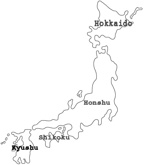
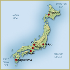 Japan
is an archipelago.
While there are thousands of smaller islands, there are four major islands
that make up the archipelago. These islands
are Honshu, Hokkaido, Kyushu and Shikoku. The most important of the smaller
chain are the Okinawa
Islands in the south and the Kuriles in
the north. Both are significant historically in the twentieth century. Okinawa
was important in the end of World War II and ownership of the Kuriles was an
issue with the former Soviet Union. Due to the fact that Japan is made up
of
islands, it is surrounded by a variety of bodies of water. Between the mainland
of Asia and Japan is the Sea of Japan. At the northern tip of Japan, is the
Okhotsk Sea. At the southeastern tip is the East China Sea. To the West of
Japan, is the Pacific Ocean. Between the major islands of Shikoku, Honshu,
and Kyushu
is a body of water called the Inland Sea.
Due to its island nature, water is extremely important to Japan. While there
are many rapidly flowing rivers they are largely nonnavigable.
The longest river is the Shinano River at just over 200 miles long. As industrialization
rose, the importance of fast running water became important for hydroelectric-power
generation. Around Japan flow three main ocean
currents. The salty warm-water current on the southeastern side of
Japan has a purple appearance and is called Kurochio (Black Current). A second
warm water current flows northward from the southern coast of Kyushu through
the Sea of Japan and is called the Tsushima Current. .The cold water current,
the Kurile Current flows south toward the kurile Islands and the major island
of Hokkaido. Where the warm and cold currents meet is excellent fishing grounds.
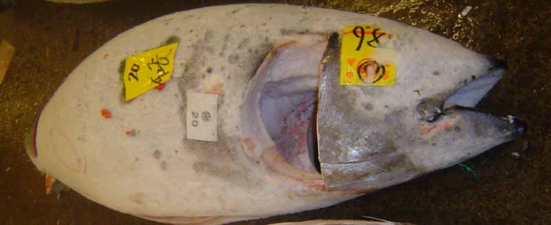
The island setting of Japan leads to a diet of primarily fish. Japan's largest
wholesale fish market is Tokyo's Tsukiji
Fish Market. There fish like tuna are
auctioned off in the early hours of the morning. Click here to see video
of an auction at the fish market.
Japan
is an archipelago.
While there are thousands of smaller islands, there are four major islands
that make up the archipelago. These islands
are Honshu, Hokkaido, Kyushu and Shikoku. The most important of the smaller
chain are the Okinawa
Islands in the south and the Kuriles in
the north. Both are significant historically in the twentieth century. Okinawa
was important in the end of World War II and ownership of the Kuriles was an
issue with the former Soviet Union. Due to the fact that Japan is made up
of
islands, it is surrounded by a variety of bodies of water. Between the mainland
of Asia and Japan is the Sea of Japan. At the northern tip of Japan, is the
Okhotsk Sea. At the southeastern tip is the East China Sea. To the West of
Japan, is the Pacific Ocean. Between the major islands of Shikoku, Honshu,
and Kyushu
is a body of water called the Inland Sea.
Due to its island nature, water is extremely important to Japan. While there
are many rapidly flowing rivers they are largely nonnavigable.
The longest river is the Shinano River at just over 200 miles long. As industrialization
rose, the importance of fast running water became important for hydroelectric-power
generation. Around Japan flow three main ocean
currents. The salty warm-water current on the southeastern side of
Japan has a purple appearance and is called Kurochio (Black Current). A second
warm water current flows northward from the southern coast of Kyushu through
the Sea of Japan and is called the Tsushima Current. .The cold water current,
the Kurile Current flows south toward the kurile Islands and the major island
of Hokkaido. Where the warm and cold currents meet is excellent fishing grounds.
The island setting of Japan leads to a diet of primarily fish. Japan's largest
wholesale fish market is Tokyo's Tsukiji
Fish Market. There fish like tuna are
auctioned off in the early hours of the morning. Click here to see video
of an auction at the fish market.
 Japan
is land is over 50% mountainous. This affects where the Japanese live and how
they make their living. Less than 20% of Japan is arable.
This leads to terrace farming
being used in the mountainous areas. The average family farm in Japan is
less than 3 acres. One resource that Japan has is an abundance of forests. Almost
70% of the land is covered by forests but the mountains prevent the full development
of the timber industry. While there are
over 500 mountains that are over 1 mile high, the most famous mountain is Mount
Fuji. Japan's highest point, it can be seen from Tokyo on clear days. The
mountain is almost 3800 meters or approximately 2.3 miles high. The temperature
on the mountain top during climbing season ranges from 46 degrees Fahrenheit
(8 degrees Celsius) to 64 degrees Fahrenheit (18 degrees Celsius). Due to its
height and the climate of Japan, climbing season is from July 1 to August 31.
Anytime before June or after September may find snow at the mountaintop making
it too unstable to climb without proper equipment for winter climbing. While
in June and September it may still be warm enough to climb, the rainy season
in June and typhoons
in September make the climb dangerous. It's perfect shape has caused it to be
considered sacred and worshiped. It has also been the focus of the arts, particularly
literature, painting, and photography.
While Mount Fuji is beautiful, it is a volcano.
Ten percent of the worlds active volcanoes are in Japan. This leads to an abundance
of hot springs or onsens in Japanese.
Japan
is land is over 50% mountainous. This affects where the Japanese live and how
they make their living. Less than 20% of Japan is arable.
This leads to terrace farming
being used in the mountainous areas. The average family farm in Japan is
less than 3 acres. One resource that Japan has is an abundance of forests. Almost
70% of the land is covered by forests but the mountains prevent the full development
of the timber industry. While there are
over 500 mountains that are over 1 mile high, the most famous mountain is Mount
Fuji. Japan's highest point, it can be seen from Tokyo on clear days. The
mountain is almost 3800 meters or approximately 2.3 miles high. The temperature
on the mountain top during climbing season ranges from 46 degrees Fahrenheit
(8 degrees Celsius) to 64 degrees Fahrenheit (18 degrees Celsius). Due to its
height and the climate of Japan, climbing season is from July 1 to August 31.
Anytime before June or after September may find snow at the mountaintop making
it too unstable to climb without proper equipment for winter climbing. While
in June and September it may still be warm enough to climb, the rainy season
in June and typhoons
in September make the climb dangerous. It's perfect shape has caused it to be
considered sacred and worshiped. It has also been the focus of the arts, particularly
literature, painting, and photography.
While Mount Fuji is beautiful, it is a volcano.
Ten percent of the worlds active volcanoes are in Japan. This leads to an abundance
of hot springs or onsens in Japanese.
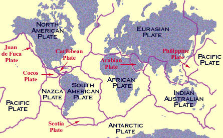
Japan is also located at the meeting of four tectonic plates. The Eurasian, Pacific, Philippine, and North American Plates meet in the location near and on the meeting of tectonic plates increases Japan's chance at earthquakes. Most of the earthquakes occur below or close to the ocean. These will often create a tsunami. The most severe earthquake hit the Tokyo area in 1923. Over 100,000 people died and it is called the Great Kanto Earthquake. In January1995, an earthquake struck the area of Kobe. This earthquake is called the Southern Hyogo Earthquake or the Great Hanshin Earthquake. Over 6,000 people were killed. This particular area, until this earthquake was considered to be relatively safe. In Japan, the Richter scale is not as commonly used as "shindo" scale. This system refers more to the intensity of an earthquake at a given location. The scale ranges from one to seven. Minor earthquakes are three and under while heavier damage is from five to seven.
Click
![]()
to return to Mrs. O'Donnell's Home Page.
"Maintained according to the Lakeland
Central School District Web Page Policies and Guidelines."
“Clicking on the above links will direct you to site(s) outside the Lakeland
Central School District and the Lakeland High School server. The Lakeland Central
School District is not responsible for contents on external sites and servers,
nor does the district endorse the sponsors or advertising on these sites.”
This site was designed and maintained by Maureen
O'Donnell, a teacher at Lakeland
High School.
July 2005 Created - |
Wednesday, February 1, 2006
Last Revised -