| Remarkable, you found the missing Rhode Island State Quarter! | |
| Click
here to go back to the Capitol to find the remaining missing quarters. |
Investigate The State Quarters |
|
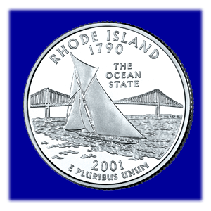
Rhode
Island became a state on May 29, 1790 making it the thirteenth state
in the United States. The Rhode Island State Council on the Arts was
asked by Governor Lincoln Almond to set up a panel to look over the
quarter designs submitted by the people of Rhode Island. Three designs
were chosen from over 500 designs. Rhode Islanders were able to vote
for their favorite out of the three by voting at libraries, the Statehouse
and through the Internet. Fifty-seven percent of the votes were for
the sailboat design.
Rhode Island is the smallest state in the United States, and it has over 400 miles of land that borders the ocean. That is why it is known as the "Ocean State." Therefore a bay, bridge, and sailboat are pictured on the Rhode Island Quarter. Tourists visit the state each summer to enjoy boating, fishing, water-skiing, and swimming. |
|
|
The bay pictured on the quarter is Narragansett Bay that flows into
the Atlantic Ocean. The bay goes 28 miles inland from the ocean. This
almost cuts Rhode Island in half. The U.S. Navy has several buildings
along Narragansett Bay. Two are the Newport Naval Underwater Systems
Center and the Naval War College. Many of Rhode Island's rivers run
into the bay including their three main rivers, Providence, Sakonnet,
and Seekonk. The bay's name comes from the Narragansett Indian tribe.
The bridge is the Claiborne Pell Bridge. In the 1940s plans were made for the bridge, but it wasn't completed until 1969. The bridge was named after a past governor, named Senator Pell. Most people know this bridge as the Newport Bridge because it connects the towns of Newport and Jamestown. Before the bridge was built, a ferry connected the two towns. Newport is located on the shore of Narragansett Bay. Nine families from the Massachusetts Bay Colony founded the town in 1639. The colony wanted religious freedom and thought an education was very important. In 1763 the Touro Synagogue, a Jewish house of worship, was built. It is the oldest synagogue in the United States. From 1775 to 1783 Newport, Boston and New York City were important seaports. In 1884 the Naval War College was opened. It is the U.S. Navy's highest educational college. Also, in the late 1800's wealthy railroad and banking families built and entertained in beautiful mansions. Jamestown is on the other side of the Pell Bridge. Jamestown is located on Cananicut Island. It became a town in 1678 with 150 people living in Jamestown. A windmill was built for grinding corn and used the sea breeze, (winds that come off the sea) for power. At that time there was no running water to turn the wheel. In 1775 during the Revolutionary War the British burned the town. Most of the townspeople left the island. They occupied the town until 1779. The British burned forts in Jamestown and the Beavertail Lighthouse. In 1873 a ferry service was available between Jamestown and Newport. The ferry brought people to Jamestown to live and vacation, so houses and hotels were built. The sailboat shows the love Rhode Islanders have for sailing. The state is known as the "sailing capital" of the world. One reason is that the America's Cup was won by the United States for more than 50 years. In 1851, a boat race was held in England. The boat "America" won the race beating 14 boats from other nations. The America won a trophy that became known as the America's Cup. From 1851 to 1980, boats representing the United States won every America's Cup race. During those years the race was held in Rhode Island on Narragansett Bay. The nation who wins the race hosts the next year's race in his country. |
|